Template:PM map: Difference between revisions
From the Super Mario Wiki, the Mario encyclopedia
Jump to navigationJump to search
m (+toad town dojo) |
No edit summary |
||
| Line 36: | Line 36: | ||
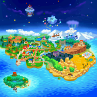
rect 37 236 56 251 [[Mt. Lavalava]] | rect 37 236 56 251 [[Mt. Lavalava]] | ||
rect 35 260 75 272 [[Jade Jungle]] | rect 35 260 75 272 [[Jade Jungle]] | ||
rect 40 262 76 275[[Yoshi's Village]] | |||
poly 53 303 11 271 11 260 26 250 48 247 62 247 86 257 92 261 94 268 95 281 88 289 71 292 63 288 56 289 [[Lavalava Island]] | poly 53 303 11 271 11 260 26 250 48 247 62 247 86 257 92 261 94 268 95 281 88 289 71 292 63 288 56 289 [[Lavalava Island]] | ||
</imagemap><noinclude>[[Category:ImageMap Templates]]</noinclude> | </imagemap><noinclude>[[Category:ImageMap Templates]]</noinclude> | ||